Services

Wetland Delineation

Boundary determination for wetlands is a critical first step in determining the potential impact of a proposed project on this regulated aquatic resource. A Professional Wetland Scientist (PWS) is internationally recognized as the most qualified specialist to complete this task. Photo: Irrigation-supported wetland near Ellensburg, WA.

Ordinary High Water Mark

Regulated lakes, rivers, and streams often require offset buffers to protect them from encroachment. Demarcation of the ordinary high water mark (OHWM) is a prerequisite step in determining the precise limit of the jurisdictional buffer radius. Photo: Yakima River near Gleed, WA.

Mitigation Planning

If a project cannot avoid wetlands, streams, or their regulated buffers, mitigation for impacts may be required. A wetland and/or stream mitigation plan contains a description of the impact, details of the mitigation proposed, a monitoring and management strategy, and success criteria for regulatory permit closeout.

Permitting Assistance

Construction near wetlands, streams, or other sensitive habitats can require a variety of permits. Whether it be ESA consultation, completing a JARPA, applying for an HPA, helping with SEPA compliance, or obtaining a local building permit, GG can assist you.

Habitat Assessment/Wildlife Survey

Many habitats and species are protected by state and/or federal law. If your project occurs within a habitat zone identified as rare or potentially utilized by a protected species, an assessment of a project's potential impact on these resources is likely to be required. Furthermore, impacts may require mitigation. Photo: Shrub-steppe/wildlife survey near Moxee, WA.

Ecological Integrity Assessment

An Ecological Integrity Assessment (EIA) is an approach to systematically rate the current ecological integrity of a plant association or ecological system. The EIA framework provides a standardized currency of ecosystem integrity across all terrestrial ecosystem types. This information can then be used for setting conservation priorities, identifying restoration strategies, and monitoring the effectiveness of conservation actions. Photo: Mima mounds in scabland along Cow Creek, Adams County, WA.

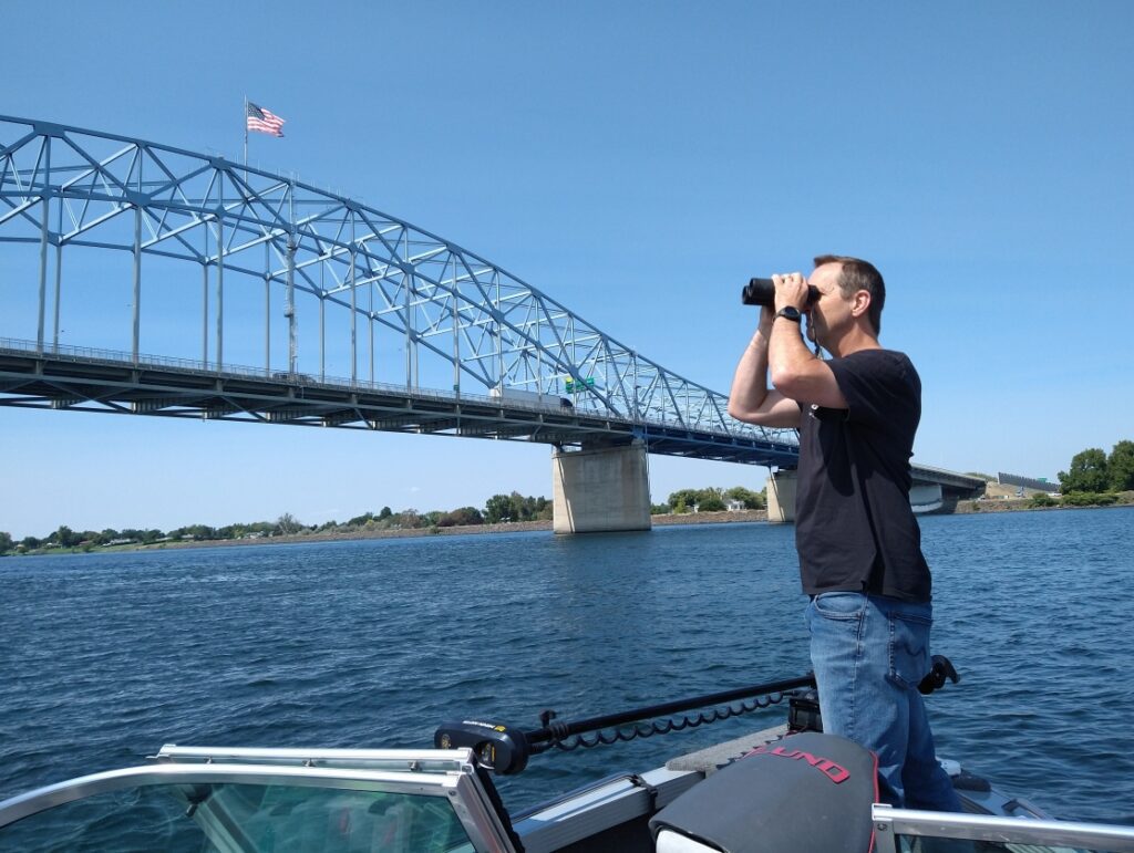
Bird Protection/Construction Monitoring

Federal law protects most birds and the penalties for harassing, harming, and/or killing birds, eggs, or young are really steep, including large fines and/or prison time. GG conducts baseline bird surveys, prepares bird protection plans, trains staff, and performs construction monitoring to mitigate potential impacts to birds. Photo: bird nest survey from the GG boat at the US 395 Pioneer Memorial Bridge.

GPS Survey

Geospatial documentation of targets in the field is completed using a Juniper Systems Geode Global Positioning System (GPS) receiver capable of sub-foot horizontal accuracy. Connected via Bluetooth to a mobile phone, this light equipment is easy to transport through dense brush and across uneven terrain. Photo: GPS work along the Yakima River near Ellensburg.

Forest Stewardship Planning

If a forested parcel is designated by a county as Forest Land, a Forest Stewardship Plan (FSP) is required when the parcel changes ownership.  A FSP outlines the committments the landowner will make to reduce and prevent insect and disease infections, reduce wildfire hazard, enhance and maintain habitat for wildlife, and maintain a full stocking of trees for eventual harvest. Photo: designated forest land near Goldendale, WA.

Shrubsteppe Surveys

Many state and federal agencies, tribes, and nonprofit organizations have initiated programs to protect, restore, and enhance shrubsteppe. Shrubsteppe is listed by many Eastern Washington counties as a Fish and Wildlife Habitat Conservation Area while the Washington Department of Fish and Wildlife (WDFW) designates shrubsteppe as a Washington State Priority Habitat. Photo: lichen-covered flood erratic in a shrubsteppe coulee NW of Ritzville, WA.

Grant Writing and Support

Grant writing is a critical element required to access public funding for proposed projects. Excellent organizational and writing skills are required to sift through volumes of material and to package vital data into a clear, concise grant application that makes the project stand out and beat the competition.

Critical Areas Training

GG offers FREE critical areas training for realtors interested in learning more about how to better advise their clients during real estate transactions. Photo: 2023 training given at Berkshire Hathaway (Gina Styler) in Ellensburg, WA.